Mt. Sefuri
|
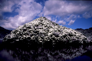
Fukuoka is known more for its pristine beaches than its rugged mountains, but the prefecture still has fair claim to pleasant hiking routes with panoramic views and a little history. At least one peak, Aburayama, is visible from Fukuoka city and its trail head is easily accessible by city bus. But for more challenging and inspiring routes, head for the Saga border. Mt. Sefuri is, at 1055m, the tallest peak along the ridge line that separates the two prefectures, falling slightly short of Mt. Hiko’s 1200m on the Oita border. For that reason, Mt. Sefuri is sometimes overlooked by casual hikers. It is on the list of Japan’s 300 great climbing mountains, but shouldn’t prove too terribly challenging, even in inclement weather. There are about seven established courses along the range, which take anywhere from four to seven and a half hours. They have been rated beginner to intermediate. The peak, like many in Japan, is home to radar stations and other equipment, but that shouldn’t ruin appreciation of the climb through fresh air, or the stunning views at the top. In the autumn, the foliage is an attraction for many, while more adventurous types even hike up through light snow. Part of the trail on Mt. Sefuri is a link of the 2587km Kyushu Nature Trail. Until the late 19th century, Sefuri was a center of Shugendo religious practice and the mountain’s ‘hikers’ were predominantly priests. Remnants of the mountain’s religious legacy are still visible here and there, from old shrines to forgotten ruins. The 12th century priest Eisai is said to have first planted tea on Mt. Sefuri following his return from China, making it the birthplace of tea in Japan. Most hikers leave from the Nishitetsu Bus line’s Shiiba stop, though other bus stops in the area also offer trail heads. For more detailed information (in Japanese): |
 福岡は起伏の激しい山々よりも、その手付かずの海岸でよく知られている。しかしこの県には素晴らしいパノラマとちょっとした歴史を持つ、楽しいハイキングルートがある。そんな山のひとつ、油山は、福岡市内から姿を望むことができ、尾根道へのアクセスも市バスで簡単だ。一方佐賀との県境に向かっては、より困難で意欲をかき立てられるようなルートもある。 1,055mの脊振山の頂上は二つの県を隔てる稜線上にあり、大分との県境にある英彦山 1,200mよりも少しばかり低い。そのため脊振山は、カジュアルに山歩きを楽しむ人々からは見落とされることが多い。日本三百名山のひとつでもあるが、荒れ模様の天気であっても困難すぎるというほどではない。7つほどのコースがあり、いずれも4時間から7時間半で巡ることができる。初心者から中級者向けと言ってよい。 同規模の他の山と同様、レーダーサイトなどの施設があるものの、新鮮な空気や山頂からの見事な景色といった山登りの楽しみを台無しにするものではない。秋には紅葉が多くの人々を惹き付け、軽い積雪の頃には冒険好きな人たちが集まってくる。脊振山のハイキングルートは、総延長2,587kmの九州自然歩道につながっている。 19世紀後半までは修験道の中心地であり、登山をする人は修験者がほとんどであった。修行の場であった名残りは、古い神社から忘れ去られた廃墟まで、今なおあちこちに見ることができる。12世紀に栄西禅師が中国から持ち帰ったお茶を日本で初めて栽培したことにより、日本のお茶の発祥地と言われている。 このエリアには他の登山口もあるが、西鉄バスの椎原バス停留所から入る登山者が多い。詳しい情報(日本語のみ)や写真は、福岡市のウェブサイトをどうぞ。 |


